
Where are the highest areas of elevation in Texas? (Details follow)
I am not talking about one hill…I am wondering if Texas has an area that is high in elevation and high above sea level. Someone asked me and I didn’t know…I always think of Texas as flat (except for the Hill Country.)
I know that the Hill Country must be an area that is high above sea level (possibly?) But are there other areas? If so, how high are they? (I am sure some Texans may well know the answer to this.)
Thank you in advance.
Observing members:
0 Composing members:
0
Composing members:
0
6 Answers

If you look at a Texas relief map, you can see that much of western Texas is well above sea level, especially the part southwest of the panhandle.
The panhandle is the part of the state that projects northward from the rest of it.
From what I could tell from a cursory scanning using Google Earth, much of that area is about 4,000 feet (1,220 meters) above sea level.

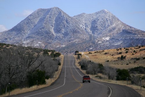
The highest peak is located in a group of mountains in Guadalupe Mountains National Park, in West Texas, almost to the New Mexico border. The highest elevation there is Guadalupe Peak (8749 ft.).
Then there are the Davis Mountains southwest from there, where there’s an observatory. Highest elevation is 8382.
Big Bend National Park, further south still, has Emory Peak in the Chisos Mountains (elevation 7825 ft).
I grew up in Houston, on the Gulf Coast, and the terrain there is very much like you’ve imagined. I used to drive to Big Bend every chance I got, just to escape the flatness, but from Houston to Big Bend was a 10 hour drive! Texas is pretty damned big.
@Brian1946 and @thorninmud…Thanks for the great information/answers.
Lurve coming to you…....I had no idea about this whole area…...!
That relief map was really interesting @Brian1946 as were the links @thorninmud
Stunning beauty….i am now officially incredibly and irretrievably homesick

@DarlingRhadamanthus basically from the coast the state would elevate with the west being the highest part, and the panhandle being flat. Driving from Waco to San Angelo to visit my buddy, I always noticed the elevation starting to pick up a bit around Golthwaite. Even though in San Angelo it’s kinda flat the mesas and buttes start appearing until you get all the way into the mountains over around the New Mexico border.
@jlelandg…..........Thanks for the information….....lurve coming…....:)
Answer this question 
This question is in the General Section. Responses must be helpful and on-topic.


