General Question

DominicX's avatar

Why are the labels on Google Earth so far off-center?

Asked by DominicX (28808points) May 16th, 2010

Maybe this wouldn’t bother most people, but I am asking people here who use Google Earth or have Google Earth on their computer if they see certain labels (such as the labels for U.S. states and counties) as being off-center.

This wasn’t always a problem for me, but it is now. Here’s what I mean:

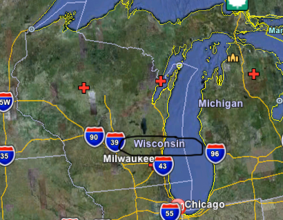
Wisconsin‘s label is way off-center.

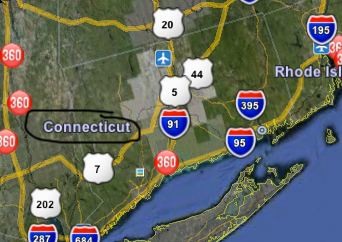
Connecticut‘s label is way too far off to the west side of the state.

Does anyone else see the labels like this? I’ve noticed this in Australia too. However, when you look at Mexico, all the labels are perfectly centered.

Observing members: 0 Composing members: 0

4 Answers

dpworkin's avatar

I don’t see that. Could it be a browser-rendering problem?

Buttonstc's avatar

I wouldn’t necessarily get too worked up about States on the Northeastern seaboard as they are all jammed together anyway on pretty much any map, regardless.

Is this also happening with the squarish states in the Midwest ? That would be a little easier to determine centrality with, right?

Kayak8's avatar

I have noticed it too. It seems related to zooming in and out—there is a level of zoom where most things are centered but when you zoom back out they “bounce” to a location to allow everything to fit.

DominicX's avatar

@Buttonstc It happens there too. :(

I also wonder why it only happens in the United States, Canada, and Australia. Seriously, I went all through Europe and Latin America and didn’t notice this problem.

Answer this question

Login

or

Join

to answer.

This question is in the General Section. Responses must be helpful and on-topic.

Your answer will be saved while you login or join.

Have a question? Ask Fluther!

What do you know more about?
or
Knowledge Networking @ Fluther